We couldn’t see a safe way to actually get on Gulkana Glacier during our previous hikes – we were stymied right at the edge of the glacier due to being unable to cross the crashing current. We know that some people have hiked right up onto the unstable moraine in the brittle zone at the foot of the glacier in previous years, but glaciers morph every year… and that way, too, seemed risky at this point. We decided to try an “over the top approach”.

Gulkana Glacier Overlook
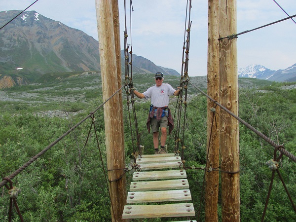
We waited for a good weather day, and packed for a 2 day overnight trek. This time, after we crossed the suspension bridge, we stayed alert for a trail to the right, which we hoped would enable us to ascend to the peak of the moraine and get past the the unstable end moraine and the creek coming out of Gulkana – success!!!
Only about a tenth of a mile or so after crossing the suspension bridge we encountered a very small trail that did a right diagonal in the general direction we had hoped to be able to go. We took it – it was narrow and at times hard to see, but it did gradually rise, until we were actually on top of the moraine and headed in the right direction. After a mile or so, we were able to see some beautiful tundra, far down to our right, which would have been much easier walking than the moraine peak we were on, however there didn’t seem to be any reasonable way to reach it off the moraine, and we were not sure where it might lead if we did the work to get down to it. (In retrospect that would have been a good approach.)

Rugged Landscape on the Moraine
To look at a moraine, you would think that it was like any other rocky boulder climb. But it isn’t. Most rocky slopes (such as along a shore) have some degree of stability. Most piles of boulders have been around for a long, long time, and have “settled” and interlocked in place. In many cases they are firmed in place with dirt or sand or loose gravel. Sometimes they are stabilized by a thin layer of topsoil created by the action of mosses, lichens and other plants that break down the rock itself. Given enough time. Not so with a moraine. It is as if a giant spilled his enormous pile of blocks in a heap. Yesterday.
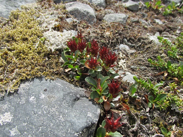
A Multitude of Alpine Plants Stabilizing Rocks on an Older Moraine

Lichen Rock Art
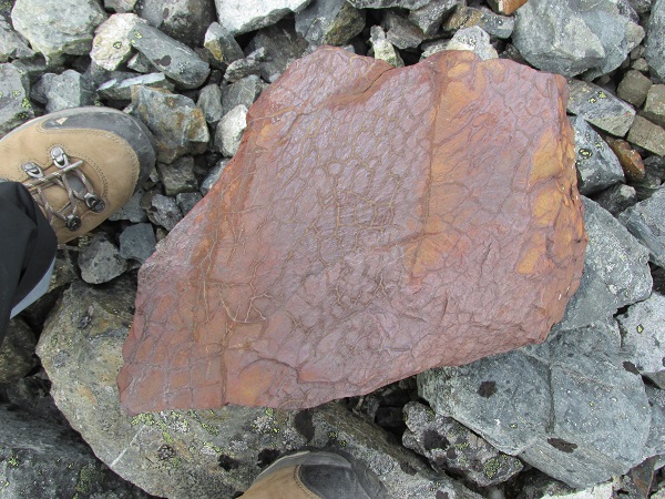
Once-Upon-a-Time Mud Now Rock
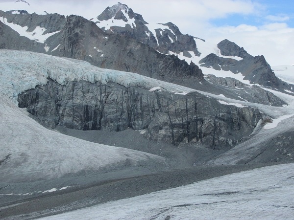
We stuck with the path we were on, though the footing was difficult, and in another mile or so we could see Gulkana Glacier below us to our left.
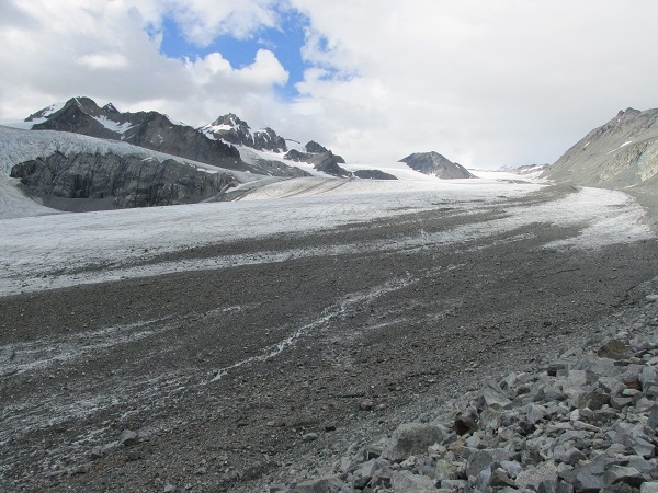
Meltwater Streams on the Glacier. It Looks So Close. (It Isn’t!)
The moraine we were on descended to a creek basin that we felt was probably created by glacial run off. It was dry, with no water flowing through at that time. Once we got ourselves down to it, we located a high point where we could pitch our tent on sandy gravel. (In retrospect that was probably a dangerous idea. Every year campers die when their campsite floods unexpectedly, and we could see clear signs of water flow in the sand bar. Hmmm.)
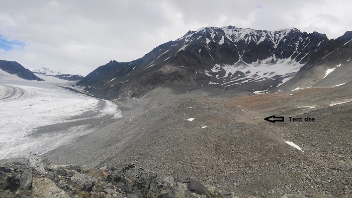
Tent Camp Behind Moraine

Gulkana Glacier Tent Camp
We set up the tent, and once finished, grabbed our “kitchen” and walked a couple of hundred yards upstream (and upwind) to cook our supper, good “bear country” camping practice. (Side note: on this entire expedition we have seen no evidence of bears – no tracks, no scat – but we have continued to carry bear deterrent spray and treat our food and trash as if bears were present.) Anyway, continuing up wind, we found a flat rock and set up our Whisper Jet stove and boiled 2 cups of water for our Mountain House meal of Chicken Rice Teriyaki, which was delicious!

Whisper Jet Set-Up
Once supper was done, and the dishes washed and put away, we decided to ascend the moraine between us and the glacier. Our goal was to descend the moraine onto Gulkana’s surface and walk about a bit. That’s one great thing about this time of year in Alaska – the day just never ends until you’re exhausted. It was quite a hike – both Linda and I have no problem with up, but the descent was pretty stressful, with 4 different levels. We’d think we had one more ridge to get over and down to the surface of the glacier – 4 times!

Ric Descending Moraine
Finally, we reached the level of the ice, which was mostly covered with gravel and rocks. We donned our micro-spikes and set out. It was probably a good 200 or 300 yards until we were past the rocks and gravel and actually on the ice. Then we took our time to explore the amazing world of glaciers… It was a hard won reward to be sure!

Ric Hiking Across Gulkana Glacier
Rock Wall Riddled with Intrusive Igneous Dikes

On Gulkana – Looking Down Valley

On Gulkana – Looking Up Glacier
The surface was like a very icy, knobby, snow (firn) and gave a satisfying crunch as we tramped around. We encountered some very small crevices in progress that were easy to step over.

Lin Crunching Across the Glacier in Her Microspikes

Lin on Gulkana Glacier. Worth the Effort!
In the course of our 2 hour or so meander we actually came across 3 different moulins, which we had read were the cause of death (a much larger one than those we saw!) of a 9 year old boy out on a snowmobile outing with his family. Moulins and crevasses can be exceedingly dangerous. Even the small moulins we saw were pretty impressive features – not that wide, but extremely deep from what we could see. You can hear the sound of the water swirling and falling and echoing, as if into a deep, deep well.

A Small Moulin on Gulknana Glacier
I estimate that we walked between 1/2 and 2/3 of the way across the lower end of the glacier when we decided that given our days’ walk and what we had left to do before we got “home” we would head back. When we felt we had reached the edge of the glacier and bottom of the moraine, we found a rock to sit and doff our micro spikes. Looking at the moraine, we could see how the ice continued inside (beneath the rocks) and up quite a ways. Kind of makes you wonder where solid “ground” began!

Lin Hiking Up the Moraine
By the time we made it back to camp, we were both very tired. All thoughts of reading or journaling quickly evaporated once we were in the tent and horizontal. As we approached camp, I noticed that there was a significant flow of water that had not been there when we left. Apparently it had rained higher in the mountains and we were just now getting the run off. We began to doubt the wisdom of our tent placement and used rocks to deepen the stream bed around the tent and built small banks to help the water divert around our tent. Soon we had water flowing on both sides of the tent (which was only 3 or 4 inches higher than the channel the water was flowing in). Still, there was really no better place to put the tent, the sky was fairly clear, and the forecast was favorable. So we called it a night (a very restless night.)
The next morning, amongst grunts and groaning, mostly by Ric, we popped up right around 5 AM. It felt very cool – somewhere in low 40’s. Lin was VERY pleased with the new sleeping mat that Lyric and Matt had sent her bought for her birthday. The mat plus the thermolite liners and Jack R Better Sleeping Bags kept us warm into the 30s for very little pack weight.

Cool Indeed! There is ICE on that Water!
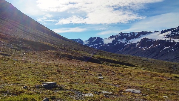
The water which had been flowing on both sides of the tent when we went to sleep, was completely dried up – though another stream was still flowing out from rocks, just downstream from our camp. While Lin got organized, I walked the 100 yards or so to our food stash and retrieved it for our breakfast and day’s travel. Once we had some chow, we broke camp down and packed for our return hike. We were able to establish the route along the peak of the moraine. After a quarter to half a mile, I noticed a trail at the foot of the moraine that appeared to be parallel to our path and we decided to check it out – which meant another moraine down slope to negotiate. Once on that trail, it led to the tundra section we had seen during our hike in.
From that vantage, we could see College Creek, and we decided to head along the base of the hills and try to get to a point where we’d be able to see College Glacier. We named this valley “Cross Glacier Valley” because you could get to either glacier from that point.
The tundra was much easier hoofing than the moraine and at one point we both thought of the them from the “Sound of Music” – you know – “The Hills are Alive, with the Sound of Music…”.
The Hills are Alive…
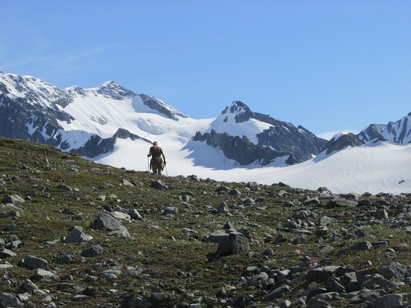
Ric Approaching College Glacier
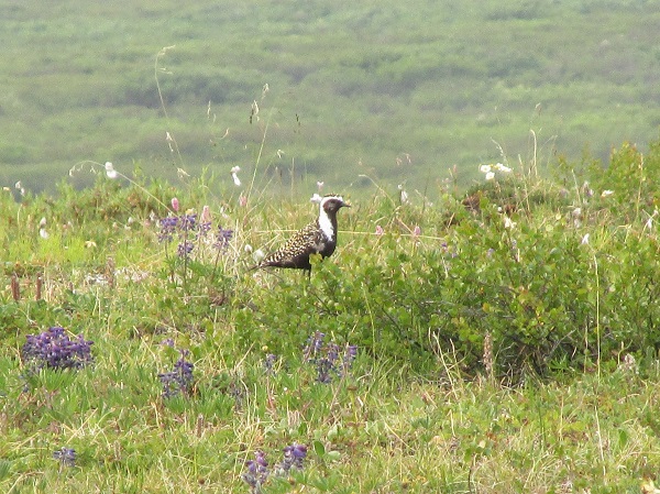
We saw some critters along this portion of our hike, including what we thought might be a fox, but then decided was an arctic ground squirrel of giant proportions, and a mama Ptarmigan and her chicks.

Ptarmigan Wearing Granite Camo
Once we got back to our packs, we had lunch and decided to try and get down to College Creek and hike along it to get back to the suspension bridge, reasoning that it had to be easier hiking than going back up and along the peak of a moraine.

College Creek Overlook and Our Route Home
Once we got down to the creek – which was a bit of a challenge – we followed the creek for a couple of hours, encountering some stretches that were very narrow and close to fast flowing water, and then finally spotted the bridge – both quite relieved due to fatigue. It was still another half mile along the river so we elected to try bushwhacking to the trail that we had come out on. This meant scaling a fairly steep alder brush embankment.
Bad idea. After a grueling bit of this, we still had not encountered the trail and we were both completely bushed and annoyed by the small (non-biting) black flies that we disturbed in the brush. The flies tries to fly into any orifice they could find… eyes, nose, ears, mouth. We never could figure out what they wanted from us! We forged ahead. It was grueling, but we knew the direction where the bridge lay and we were not really THAT disoriented. Just dissatisfied with the available choices!
Twenty minutes later we found another trail that did in fact lead down to the suspension bridge. Only a half a mile to go to get to the truck! As soon as we got a very short distance onto the bridge it started to rain – then to pour. A suspension bridge is no place to remove your pack and don rain gear so we got fairly soaked getting across. Once there, we donned raincoats and put pack covers on, and walked the remaining distance to the truck.
As always, these kinds of hikes present challenges and we make mistakes and learn from them. They also serve to remind us of the comfort of such things as comfortable car seats at the end of the hike; a warm, dry and relatively bug proof roof over our heads; and a cold beer in the fridge!