
Here at Oliver Lee Memorial State Park there are two established trails, one is a 0.5 mile walk along the Dog Canyon Arroyo. It is a nice easy nature walk along a riparian zone near the Visitor’s Center. The other hike is a 5-1/2 mile (11 mile round trip) ball buster of a hike up Dog Canyon. It was a case of hiking feast or famine.
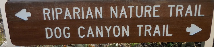
Dog Canyon is a National Recreation Trail. It starts at Oliver Lee State Park and then quickly passes into the Lincoln National Forest, ascending an escarpment into the Sacramento Mountains and terminating at Joplin Ridge and Forest Road 90B. Every sign or piece of literature describing the hike used words such as “strenuous”, “challenging”, “for serious hikers”, “knee-killer” etc. You get the idea. It has an elevation gain of about 3,100 feet and reaches an elevation of 7,782 feet. It is a FULL day of hiking along a steep and rocky trail, and it took us about 9 hours (including a half hour break for lunch and a few other shorter rest breaks).

We dipped our toe in the trail the day after we arrived at Oliver Lee, hiking to the two mile marker, and returning for a total hike of 4 miles.
 It was a hot day by our Yankee (or Red Sox) benchmarks, with temperatures in the low 80’s and strong winds. We would wait to do the full hike a few days later, when the temperatures would be in the low 70’s and the winds calmer. It gave us a taste of what was to come, and since the trail rises abruptly and relentlessly for the first half mile, it also gave us great views of the campground, the Tularosa Basin and White Sands in the distance. The windy day was lofting massive amounts of the fine white sand into the air, making it look like smoke in the distance.

Oliver Lee campground from Dog Canyon trail near beginning
We stopped in the Visitor’s Center and learned that there is much history associated with the trail. It was a haven for prehistoric peoples and later, Apaches, and was the scene of several historic battles between the Apaches and the U.S. Cavalry in the late 1800s. Placing themselves at the top of a massive cliff (the “Eyebrow”), the Apaches rained down rocks and boulders and bullets upon the pursuing cavalry soldiers, and more often than not, drove them back.

Depiction of Calvary Apache battle in Dog Canyon.
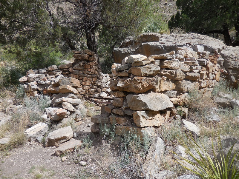
It was also the site of a ranch and land owned by Francois “Frenchy” Jean Rochas, a colorful character of the area in the 1800’s. Frenchy constructed cabins and an extensive network of rock walls, many of which still remain as a testament to his industry.

Frenchy Rock Wall Remains in Dog Canyon
The day of our hike (April 9th-Ric’s late Mom’s Birthday) was the cooler, calmer day that we had hoped for and we set out early (by our standards), getting onto the trail about 9 am. We kept a steady, slow pace up the steep inclines knowing that we had a long day ahead.

Ascending toward the “Benches” on Dog Canyon Trail
The trail is not completely relentlessly uphill. There are two flat, meadowy areas known as the “benches”. The first bench is reached a bit after a half mile of steady, steep ascent and is a welcome relief. Black-throated sparrows serenaded us as we walked across blessedly flat land, and there were an abundance of wildflowers and blooming yuccas to treat the eye.
 First Bench Dog Canyon Trail
From there the trail goes went up and down a series of large ledges, then more uphill again to the second of these two grassy meadows (about 2-1/2 miles along the trail). This is a truly lovely and peaceful little “Eden” peppered with huge boulders and lush green trees.

2nd Bench Eden: Lush Green Trees
At the end of the bench the trail rapidly descends to the site of “the Line Cabin” (just shy of 3 miles on the trail). The ruins of this cabin lie near a stately old juniper and a spring which feeds the Dog Canyon Creek. We took our lunch break there and enjoyed watching the black-chinned hummingbirds and the numerous butterflies that thrived in the riparian environment of the spring.

Spring Near the Line Cabin
Remains of Line Cabin around 3rd mile up.
The next section of trail ascended to the”Eyebrow” (a massive cliff) and one of the benchmarks of the trail. It was one of the steepest, rockiest, narrowest and most dangerous – due to precipitous drops adjacent to very narrow sections of the trail, and being continuously uphill without a break.

Nice wide part of eyebrow trail!

View of the 2nd Bench from the “Eyebrow”
In spite of the ascent, the fossil strewn landscape provided a bit of a diversion from our aching feet and acrophobia.

Fossil example along trail on approach to brow.
We were also rewarded for our efforts with absolutely spectacular views of the Canyon and the Tularosa Basin beyond. All around us we could hear the descending trills of Canyon wrens.

View from Dog Canyon to the Tularosa Basin and White Sands

Telephoto of Oliver Lee from well up Dog Canyon Trail – near top of the eyebrow.
Past the “Eyebrow” the trail continued to gain elevation up the steep and rocky terrain to mile 4.5, at which point we came to small descent into a relatively flat meadow for a short distance. Aside from being alert for rattling snakes in the grass it was a nice break from climbing.

Dog Canyon flat at 5 mi plus
Finally the trail took us up another steep (but short) ledge with switchbacks to the top of Joplin ridge. Near the end of the trail there was an area of charred trees from a past burn… something we are becoming accustomed to seeing here in the west.

Burned area at top of Dog Canyon Trail
When we say “near the end of the trail” we actually mean half-way. What goes up must come down. We knew we couldn’t linger long, so after a trail terminus pic or two we were on our way again, ready for the punishing downhill… returning as we came. Views all the way.

Linda says “Only 5.5 Miles to go!”

Downhill Along the Eyebrow
We arrived home about 6 pm, after a long day at the “office”.

Leaving Lincoln Forest sign Dog Canyon
All in all we fared well. No serious complaints except for extremely sore feet. Rocky trails take such a toll that way – and 9 hours is a simply a long time to beat your feet. Our knees held up remarkably well, and we probably have our trekking poles to thank for that. A day of rest and we’ll be ready to go -just not 11 rocky miles for a little while!

Hummingbirds, sparrows, and thrushes, oh my! What a fantastic adventure with such stellar views too! Thank you for taking us along! ❤
Thank YOU for being with us in spirit ❤
Thanks for sharing
.